The Lay of the Land
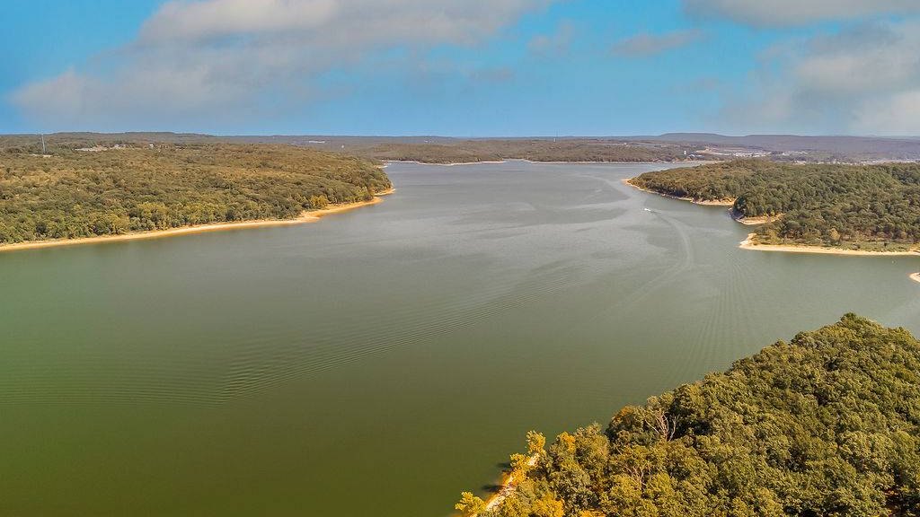
Lake Tenkiller (officially Tenkiller Ferry Lake) is a Corps of Engineers lake on the Illinois River, about 13 miles above where it meets the Arkansas River. It sits south of Tahlequah and north of Gore and Vian, across parts of Cherokee and Sequoyah counties. The Corps built the dam between 1947 and 1952, and the lake covers about 12,900 acres with roughly 130 miles of shoreline.
Cookson is a small, unincorporated community in the Cookson Hills of Cherokee County, on the lake’s east side. The Census Bureau counted 826 people in the Cookson census-designated place in 2020, and the ZIP code is 74427. Most of what people mean by “Cookson” is spread out along the shoreline and the hills around it, not a town center.
Schools and Learning
Much of the Cookson area is in Keys Public Schools, a rural district based on State Highway 82 in Park Hill. It has two schools. Enrollment below is from the National Center for Education Statistics for the 2024–25 school year.
For 2025–26, Keys said it was looking to add bus routes, and it reminds families that students who live outside the district must be approved as transfers before it can help with transportation.
How to research schools yourself: the state’s Oklahoma School Report Cards site publishes a report card for every Oklahoma public school and district, and NCES has federal enrollment data. District lines in rural Cherokee County are irregular, so confirm the district for any address you’re considering with the district or the Cherokee County Assessor. Numbers only tell part of the story, so we always suggest calling the schools and visiting.
Public Safety Resources
We’d rather point you to the source than hand you a ranking. Cookson is unincorporated, so the Cherokee County Sheriff’s Office provides patrol in the county’s unincorporated areas; the office covers about 776 square miles. Cherokee County 911 dispatches police, fire and EMS, and the Cookson Fire Department is one of the county’s fire departments.
For numbers, the Oklahoma State Bureau of Investigation publishes crime statistics by agency and county, and the FBI’s Crime Data Explorer publishes what local agencies report. Look up the areas you’re considering, compare them with anywhere else you’re looking, and draw your own conclusions.
Outdoors and Lake Life
The Corps calls Tenkiller “Oklahoma’s Clear Water Wonderland.” Around the lake you’ll find 10 marinas, more than 20 boat ramps and 14 campgrounds, including Corps parks such as Cookson Bend, Snake Creek and Strayhorn Landing. Bluffs rise as high as 200 feet along parts of the shoreline.
Swimming and diving. The water drops off suddenly outside buoyed swim areas, and the Corps warns swimmers to stay inside them. Tenkiller State Park in Vian is home to a scuba park, with sunken features like an airplane fuselage, a school bus and a helicopter. It also has cabins, Pine Cove Marina, a seasonal pool, a 1.5-mile paved trail and the Driftwood Nature Center.
Fishing. Below the dam, the Lower Illinois River trout area runs 7.75 miles down to the U.S. 64 bridge near Gore and is stocked with trout year-round. Upstream, the Illinois River and the Baron Fork are both designated Oklahoma scenic rivers.
Hunting. The Cookson Wildlife Management Area, about 15,280 acres in Cherokee and Adair counties, is about 6 miles east of Cookson on Blue Top Road.
Out on the water, the marinas cover the boating basics. Tahlequah, the county seat, is about 25 minutes north on State Highway 82 and is the closest larger town for groceries, hardware, restaurants and everyday errands. For a bigger shopping trip, Muskogee is about 50 minutes away and Fort Smith about an hour and 10 minutes.
Getting Around: Drive Times
From Cookson, approximate drive times using OpenStreetMap routing (no traffic):
The lake is long and the roads wind around it, so times from your exact spot on the shoreline can be quite different. Drive the route before you commit.
Healthcare
The nearest hospitals are in Tahlequah. Northeastern Health System – Tahlequah is at 1400 E. Downing St. Cherokee Nation W.W. Hastings Hospital in Tahlequah has a 24-hour emergency department, along with inpatient, surgical and other services; Cherokee Nation Health Services serves patients who are eligible under Indian Health Service rules.
Utilities and Water
Water at the lake depends on the property. Two rural water districts are based in Cookson: Cherokee County Rural Water District #13 and Rural Water District #16. RWD #16, for example, starts new service with an eligibility application reviewed by its hydrology engineer, then an application, a right-of-way easement and a notarized deed, and it requires DEQ’s final septic inspection report before installing a meter on new construction.
Other properties rely on a private well. The Oklahoma Water Resources Board’s well record search shows reported well logs nearby (depth to water and yield), and Oklahoma DEQ’s lab tests private well water for bacteria, nitrates and more. More on wells and septic below.
Taxes, the Basics
- Property tax: the Cherokee County Assessor values property as of January 1 each year and handles exemptions such as the homestead exemption (apply with OTC Form 921 for your primary residence) and the senior freeze. Tax rates are set by the County Excise Board, not the assessor.
- Sales tax: Oklahoma’s state rate is 4.5%. Cherokee County adds 1.75%, so purchases in unincorporated areas like Cookson total 6.25%. The county also levies a 4% lodging tax (Oklahoma Tax Commission rate chart, 4th quarter 2026).
- Income tax: Oklahoma’s top rate is 4.5% starting with tax year 2026.
This is general information, not tax advice; the Cherokee County Assessor can answer questions about a specific property.
What Buyers Should Know About Lake Property
Buying on Lake Tenkiller isn’t like buying on a private lake. The water and the land right around it belong to the public, and the Corps of Engineers manages them. Here’s what to check before you fall in love with a view. Our guide to buying rural property in Northeast Oklahoma covers the land side in more detail.
Corps land, shoreline rules and dock permits
The Corps owns the land around the lake up to its boundary line (see elevations below), so in most places a strip of public land sits between private lots and the water. The Corps’ Shoreline Management Plan for Tenkiller zones the shoreline, which determines where private docks may be allowed, and covers mowing and other uses of government land. Verify what applies to a specific stretch of shoreline with the Tenkiller Lake Office. Under the federal rules:
- A shoreline use permit is required for a private dock or other structure on the water, and for mowing or clearing vegetation on Corps land.
- Permits go only to people with legal access to the shoreline, run up to five years, and don’t transfer with the property. When a permitted property sells, the new owner has 14 days to apply for a new permit or the dock must be removed within 30 days.
- A permit doesn’t give you ownership or exclusive use of the shoreline; the public keeps its access.
- No enclosed boathouses, no living on a dock, and no grading or filling on Corps land.
Permit conditions can vary, so call the Tenkiller Lake Office (918-487-5252) about the specific shoreline before you buy, and ask the seller for any current permit.
Flood pool, flowage easements and elevation
The lake’s normal level (top of the conservation pool) is 632 feet, and the top of the flood pool is 667 feet (NGVD29). The highest level on record is 666.36 feet, less than a foot below the top of the flood pool. When the Corps acquired the land, it set its boundary around the lake at 670 feet, three feet above the flood pool. Some private land beyond that line carries a flowage easement that lets the Corps flood it. Flowage easements can restrict what you build within the easement area, including homes, so read the easement language in the deed and verify any building plans with the Tenkiller Lake Office.
What to check: the deed and title work for any flowage easement, the property’s elevation (from a survey), the FEMA flood map for the address, and whether you’ll need a Cherokee County floodplain development permit.
Septic on lake lots
Lake lots usually rely on an on-site sewage system, and Oklahoma DEQ permits them. A few rules that matter here:
- Minimum lot size is typically half an acre with public or rural water and three-quarters of an acre with a private well, and every part of the system has to be on your property or a recorded easement.
- Within 300 feet of a listed reservoir or stream in a Water Body Protection Area, DEQ requires advanced treatment that reduces nitrogen. Ask the local DEQ office whether a lot is affected.
- In a Water Body Protection Area, or within two miles of a scenic river (like the Illinois River and Baron Fork), only a soil profile, not a perc test, can be used to size the system.
- New or modified systems need an Authorization to Construct from DEQ first, and aerobic systems come with a two-year installer maintenance period that transfers to a buyer.
Wells versus rural water
If a property has rural water, ask which district serves it and whether there’s an existing meter; new service can take an eligibility review, easements and a septic inspection report. If it’s on a well, ask for the well log (or look for nearby logs in the OWRB database) and have the water tested by DEQ’s lab before closing.
Road access
Some lake property sits on private roads or long drives through the hills. Confirm that the property has legal, recorded access, not just a road people have always used, and find out who maintains the road. Our rural property guide walks through access, surveys and boundaries.
Short-term rental considerations
If you’re thinking about renting the place out:
- Check the deed restrictions and any HOA covenants first. They can limit rentals.
- Oklahoma treats lodging as taxable, and Cherokee County levies a 4% lodging tax on top of sales tax.
- If there’s a Corps-permitted dock, the permit conditions say the dock can’t be leased, rented or sublet for money.
This is general information, not legal or tax advice.
Housing and the Lake Market
You’ll find lake homes, cabins, weekend places, wooded lots and acreage in the hills back from the water. Here’s what the MLS shows for the four ZIP codes around the lake (Cookson, Park Hill, Vian and Gore). Those ZIPs include towns, farmland and river areas too, so read these as lake-area numbers, not lakefront-only numbers.
More sales, at a slower pace. 143 houses sold in the last 12 months, up from 113 the year before. The median sale was $280,000. Homes took longer to sell, though: a median of 49 days on the market, up from 26. They closed at about 96% of their final list price, but about 93% of their original list price, so many sellers came down along the way.
Prices: firming, modestly. The honest trend is price per square foot: a median of $183, up 6.8% from $172. (The median sale price rose faster, but partly because bigger homes sold this year, so we lean on price per square foot.)
Buyers have room to negotiate. On Oct 2 there were 74 houses for sale and 18 pending, about 6.2 months of supply at the past year’s pace. More than half of the houses for sale (40 of 74) have had a price cut.
Lots and land are most of what’s for sale. There were 178 land listings on Oct 2, compared with 74 houses. Lake lots in particular are plentiful: 95 were listed against 21 sold in the last 12 months, and the typical lake lot that sold went for $32,500 on about 0.8 acre. If you’re shopping for a lot, take your time and compare; if you’re selling one, price and paperwork (survey, utilities, dock status) matter.
Close to the water. Agents tag lake features in the MLS, and those tags suggest homes with lake access or a lake view are the tighter part of the market, with less supply than homes farther out. The tags are entered by hand and often left blank, so treat that as a rough read, and check the listing details on any specific property before calling it lakefront.
One more thing right now: the lake is low. On Oct 2, 2026, the Corps’ gauge read about 625.8 feet, roughly 6 feet below the normal 632-foot pool. If water access or a dock matters to you, look at the shoreline at today’s level, not just in listing photos.
Market figures: Greater Tulsa MLS data, houses and land in ZIPs 74427, 74451, 74962 and 74435, pulled Oct 2, 2026. Calculations by Greene Land and Home.
A few things to check on any lake property: Corps shoreline rules and dock permits, elevation and any flowage easement, septic and water, legal road access, and which county and school district it’s in. We’re glad to walk a property with you and help you get answers. Reach out anytime.
One more thing, and we mean it: we share public resources and data here, not opinions about which area or school is “right” for anyone. Please look through the sources below, visit in person, and decide what fits you.